
Kalyani Kanakapura Road Masterplan
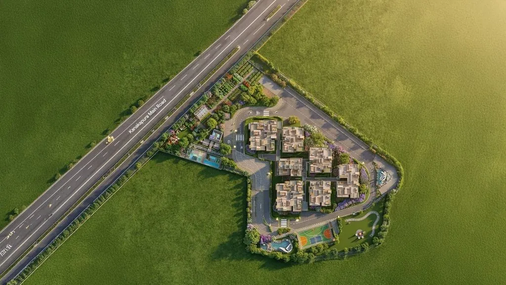
The plot, drawn
Built form set back from Kanakapura Main Road behind a planted edge. The pool, the play areas and the sports courts held inside the boundary, away from the carriageway. A landscaped court at the centre with the homes turned in towards it. The developer's own layout drawing is reproduced below in full. KNS District 30 is useful for the site-planning lens because buyers should read open space, movement, parking, and amenity placement as everyday-use details, not brochure decoration.
Then read it against the legend printed on the same page. That legend says Residential Tower (33 floors), and the key features panel beside it says Single Tower, ~180 Units. The drawing shows eight separate low-rise blocks, each three or four storeys by the shadows, around a landscaped court with a tennis court and a children's play area. It does not match its own legend, and it does not match the deck's render of one slender tower.
Both come from the same page of the same document, so both are published here. A master plan is read as fact - where the tower sits, where the amenities are, which way the homes face - and only the sanctioned plan binds anyone to it. That is the one to ask for.
The site, in numbers
About 2.5 acres
The site area given on both the specification page and the master plan page. It is not a filed figure - there is no RERA registration - so it is the developer's own number.
One tower, two wings
Described as a singular tower of two private wings, with the stated design intent of no common walls between homes.
About 33 floors
Stated as "~33 floors". No basement count and no building height are published anywhere in the deck.
About 180 homes
Roughly 72 homes per acre on the deck's own numbers. No unit mix and no per-floor stack is given.
Three high-speed lifts
About 60 homes per lift. This is the only hard servicing number in the deck.
Roughly 600 m off the main road
Derived from the deck's own distance table, not from a boundary. Its master plan page shows the plot fronting Kanakapura Main Road instead, so the two disagree.
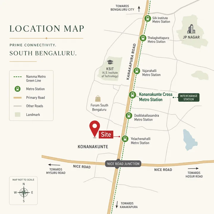
Where the site sits on the corridor
The layout drawing shows the plot; the map below shows where the plot is. The Namma Metro Green Line and Kanakapura Road are drawn to scale from OpenStreetMap, with the site position trilaterated from the deck's own distance table.
Ask for three documents before you treat any layout as settled: the sanctioned plan, the approved building plan with its floor count, and the K-RERA registration that fixes the site area and unit count in a filing rather than a brochure.
Kalyani Kanakapura Road Master Plan - Frequently Asked Questions
Is there a master plan for this project?
Yes. The deck has a master plan page, and its drawing is reproduced on this page in full. One caveat travels with it: the drawing shows eight separate low-rise blocks around a landscaped court, while the legend beside it reads 'Residential Tower (33 floors)' and 'Single Tower'. The drawing contradicts its own legend and the deck's tower render, so treat it as a marketing layout until the sanctioned plan confirms it.
Why publish a layout that contradicts itself?
Because a buyer is better served seeing the developer's own drawing and the contradiction together than seeing neither. A master plan is read as fact - block positions, amenity locations, the shape of the plot - so it is published here with the legend that disagrees with it printed alongside. The document that settles it is the sanctioned plan.
What is known about the site layout?
Very little with confidence. The deck states a site area of about 2.5 acres, one tower of roughly 33 floors arranged as two wings, approximately 180 homes and three high-speed lifts. It gives no plot dimensions, no setbacks, no block positions, no basement count and no open-space ratio.
How dense is the scheme?
About 180 homes on about 2.5 acres is roughly 72 homes per acre. That is high-rise density on a compact plot, which is the usual trade-off for a well-connected inner location. Whether it feels dense depends on how much of the 2.5 acres the tower footprint and driveways take, and that is not published.
Does the site front Kanakapura Road?
The deck's master plan shows a plot fronting 'Kanakapura Main Road', but its own distance table puts the site roughly 600 m east of the road. The two cannot both be right. Confirm the boundary from the sanctioned plan at registration.
When will a real master plan be available?
At K-RERA registration, which carries the sanctioned plan, or whenever the developer publishes a customer brochure. Until then, ask to see the sanctioned plan rather than a marketing layout.